

ANCIENT SICYON
KILOMETERS
DURATION
ELEVATION
PROPOSED SEASON
DIFFICULTY
PHYSICAL CONDITION
TECHNICAL DIFFICULTY
STARTING POINT
Author:
A. Leontaritis
Photos:
A. Leontaritis - G. Koutrotsios
A Gravel Route Through History
A dirt-road ride that introduces us to the area of ancient Sicyon in Corinthia, between the coastal zone and Mount Mikri Ziria. The route follows accessible gravel roads through fertile olive groves and vineyards, passes through impressive gorges, and ends with a wonderful descent to ancient Sicyon—a unique archaeological surprise!
INTRODUCTION
The route begins in Vasiliko, Corinthia (Ancient Sicyon), a small village built on the southeastern edge of a triangular plateau at 140 m altitude. The central Byzantine church of the Holy Trinity, built in the 13th century, stands out. It was constructed using stones and marbles from ancient temples and buildings of ancient Sicyon. The significant archaeological site of Ancient Sicyon lies to the west of the village.
Although Sicyon was one of the most important art centers of antiquity, it remained in the shadow of the famous Corinth. The original name of the area was Aigialeia, and the city was renamed Sicyon in honor of the mythical hero Sicyon, its first settler. Archaic and Classical Sicyon was a coastal city, located near present-day Kiato. According to Plutarch, Demetrius moved the city higher up, to the eastern slopes of the ancient acropolis, near today’s Vasiliko.
Sicyon was one of the most powerful cities of the Greek world, reaching its peak in the Archaic and Hellenistic periods under the tyranny of the Orthagorid family, especially under Cleisthenes, grandfather of the Athenian statesman who founded democracy. A sign of its prosperity is the Sicyonian Treasury at Delphi (5th c. BC), which still impresses visitors to the sanctuary. The Sicyonians were also the first Peloponnesians to mint coins (550 BC), depicting the head of the goddess Artemis.
From the Archaic period onwards, Sicyon excelled in sculpture, painting, and metalworking. The Sicyonian sculptor Canachos, who lived at the end of the 6th c. BC, introduced the construction of colossal statues, and many famous sculptors followed, elevating Sicyonian sculpture to the highest level in Greece. The renowned painter Eupompus of Sicyon trained some of antiquity’s greatest artists, including Pamphilos (the favored painter of Alexander the Great), Apelles, and the sculptor Lysippos.
The city’s prosperity gradually declined: it was plundered by the Achaeans and struck by two major earthquakes (153 and 141 BC). After the destruction of Corinth by the Romans in 146 BC, Sicyon experienced a brief revival, but in 87 BC it was looted by Sulla and entered the pages of history. Its importance is reflected in the many references throughout literature: Menander wrote the comedy Sicyonians in the 4th c. BC; Shakespeare mentions in Antony and Cleopatra that Fulvia, wife of Mark Antony, died in Sicyon; and Friedrich Hölderlin began his work Hyperion (1797) with the phrase “the heavenly plain of Sicyon.”


ROUTE DESCRIPTION
Starting point is the square of Sicyon, 5 km south of Kiato.The first kilometers follow the Elissonas River, on alternating gravel and old asphalt roads with gentle gradients. After the Monastery of Agios Stefanos, the gorge narrows, the route leaves the riverbed and climbs sharply through olive groves, offering beautiful views of the gorge and surrounding mountains, before reaching the village of Kryoneri. The climb essentially ends here, and the local café with its kind owners is usually open—even on winter weekdays—so a short stop is almost a must.
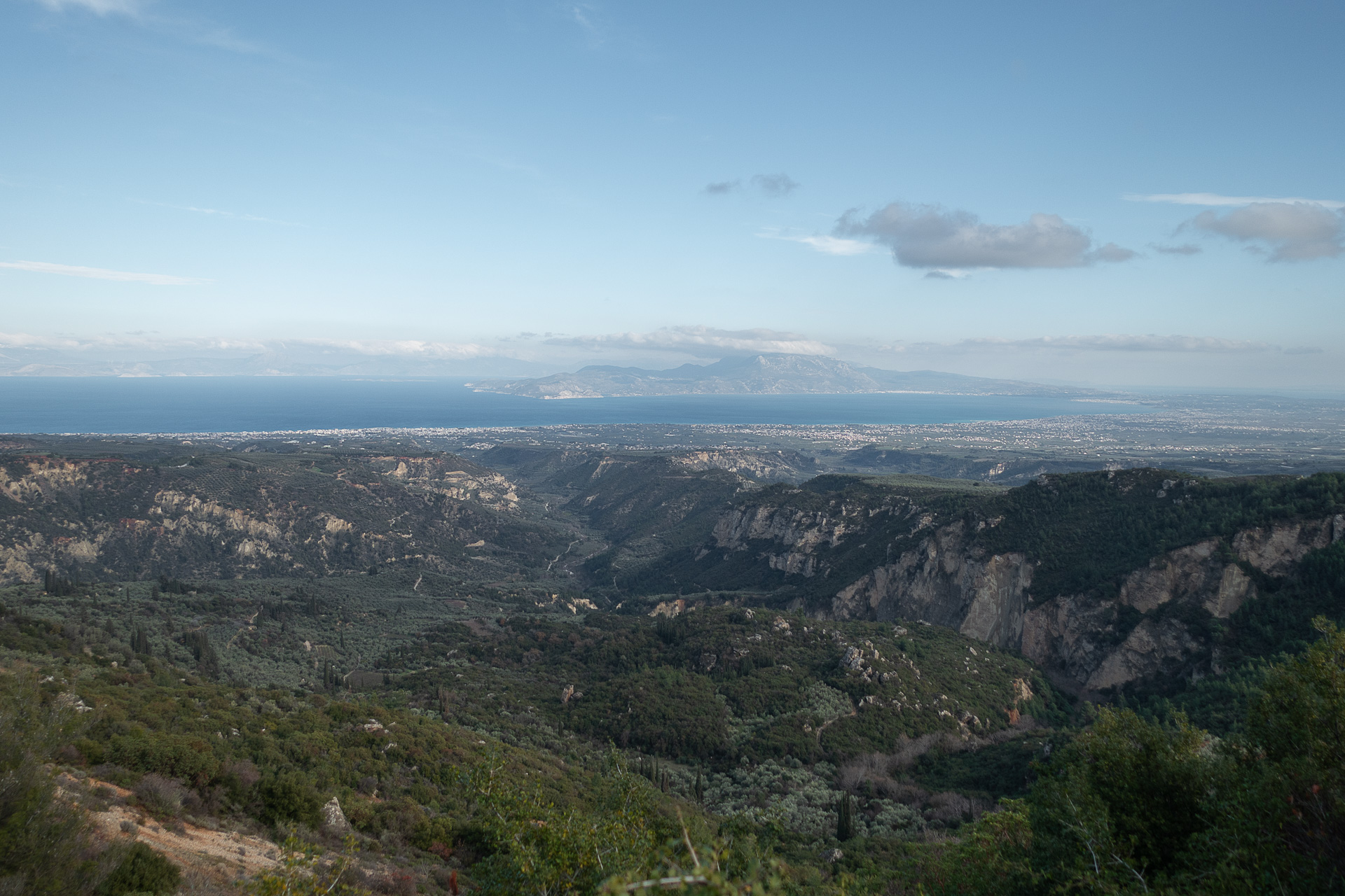
The route then dives back into the gorge, through dense vegetation, and crosses the river one last time just below an Ottoman stone bridge. A final short climb leads to the impressive ridge on the eastern side of the gorge. The descent that follows is delightful, with gentle slopes, good terrain, and unforgettable views of Parnassus, Helicon, and the Corinthian Gulf, with the Alkyonides Islands and Cape Heraion creating a stunning backdrop.
Shortly before returning to the starting point, you’ll encounter the archaeological site of Sicyon, featuring the magnificent ancient theater of the Hellenistic period and the unique archaeological museum housed in a restored Roman bath.
25.5 km.
ROAD
DIRTROAD
BAD DIRTROAD
PATH
25.5 km.
ROAD
DIRTROAD
BAD DIRTROAD
PATH
ROAD
BAD DIRTROAD
DIRTROAD
PATH
GALLERY


- POINTS OF INTEREST
The archaeological site is a beautiful place dominated by the Hellenistic theater, preserved in relatively good condition, offering breathtaking views toward the sea and the sacred mountains of Parnassus and Helicon. Carved into a natural hollow on the slopes of the Hellenistic acropolis, the theater dates from the late 4th c. BC and is considered one of the largest in ancient Greece. Today, it is undergoing restoration and excavation.
The site includes the cavea, orchestra, and stage, while two vaulted passageways at the edges of the cavea—remarkable examples of Hellenistic architecture—allowed spectator access. In the Roman era, modifications were made, mainly to the stage building. Excavations carried out over the last decade by the University of Thessaly have revealed important remains, such as the foundations of the Bouleuterion (a spacious square building with four interior colonnades), the Stoa, the Temple, and the Gymnasium of Kleinias. Northwest of the theater lies the ancient stadium, 207 m long.
All the visible monuments of Ancient Sicyon, except the Theater and the Stadium, follow the Hippodamian grid system, the characteristic urban plan of Hellenistic cities, oriented to the four cardinal points. You can see a map of Ancient Sicyon as drawn by F. Aldenhoven in 1814 here.
The Archaeological Museum of Sicyon is also noteworthy. Housed in a restored Roman bath (rebuilt by archaeologist Anastasios Orlandos in 1935) next to the site, it displays treasures of Sicyon and the surrounding region. In its courtyard and three exhibition halls, artifacts showcase the history of the ancient city and provide insight into the public and private life of its inhabitants.
ROAD BOOK
| Distance between points | Total distance | Description | |
|---|---|---|---|
| 0 | 0 |  |
Starting point: the square of Sicyon village, Corinthia. From the Agia Triada church, head first towards the archaeological site. |
| 0.2 | 0.2 |  |
At the square with the fountain, left at the fork |
| 0.2 | 0.4 |  |
At the next fork, right towards “Stadium.” |
| 0.6 | 1.0 |  |
At the junction after the stadium, right. |
| 0.2 | 1.2 |  |
At the next junction, straight on the cement road. |
| 0.1 | 1.3 | |
Next junction: straight downhill. |
| 0.3 | 1.6 |  |
At the end of the descent, left on the main asphalt road. |
| 0.2 | 1.8 | |
At the end of the village, left at the fork towards the gorge. |
| 0.2 | 2.0 |  |
At the first bend, keep left (straight) on old asphalt. |
| 0.8 | 2.8 |  |
At the small concrete bridge, right, then immediately left onto asphalt. |
| 0.8 | 3.6 |  |
After the chapel with the cypresses, left at the bridge. |
| 0.9 | 4.5 | |
At the fork, right towards the riverbed. |
| 0.0 | 4.5 |  |
After 50 m, sharp right diagonally back across the riverbed. |
| 0.2 | 4.7 | |
On the asphalt after the river, left. |
| 0.5 | 5.2 | |
At the monastery, right at the fork. |
| 0.6 | 5.8 | |
At the start of the climb, straight on dirt road. |
| 0.4 | 6.2 |  |
First fork: left (straight). |
| 0.1 | 6.3 | |
Next fork: right (left leads to the river). Same at the following fork after 50 m. |
| 0.7 | 7.0 | |
Before the cypress grove, left downhill. |
| 0.5 | 7.5 | |
Next fork: right uphill. |
| 1.6 | 9.1 | |
Next fork: sharp right uphill. |
| 0.5 | 9.6 | |
Midway on the steep climb, left uphill at the fork (right goes downhill). |
| 3.4 | 13.0 |  |
In Kryoneri village, left at the junction towards Cemetery, Stadium, and Mycenaean Tombs. |
| 0.3 | 13.3 | |
At the cemetery, right at the fork (dirt road). |
| 1.5 | 14.8 | |
After the stone spring, at the fork, right slightly uphill. |
| 0.4 | 15.2 | |
At the end of the short climb, straight at the junction. |
| 0.8 | 16.0 | |
Next junction (start of vineyards): left. |
| 0.1 | 16.1 | |
ΜShortly after, left at the fork. |
| 5.4 | 21.5 | |
Midway on the return, right at the fork (left descends to the monastery) |