

EASTERN AGRAFA
KILOMETERS
DURATION
ELEVATION
PROPOSED SEASON
DIFFICULTY
PHYSICAL CONDITION
TECHNICAL DIFFICULTY
STARTING POINT
Author:
G. Koutrotsios
Photos:
G. Koutrotsios - A. Leontaritis
Agrafa is a wild, vast land, rugged and seemingly inhospitable. Yet, once you step into it, a bond forms, evoking intense emotions and unforgettable images. Even when life pulls you away, your mind keeps cycling along its isolated roads, winding between jagged peaks and crystal-clear rivers, searching for the next chance to return.
INTRODUCTION
Visiting Agrafa is like taking a journey through time. It begins in the Cretaceous period, when the alpine mountains were still being formed, and continues through key moments that reveal the region’s proud history and resilient spirit. This is a land shaped by resistance—from the Ottoman era, when Agrafa remained unconquered, to the Occupation, when ELAS turned it into one of Greece’s first liberated areas. Today, the grassroots movement #saveagrafa has succeeded in protecting its peaks from destruction for minimal power generation, standing against unchecked “green” development.
The eastern side of Agrafa—also called Thessalian Agrafa—stretches from Lake Plastira across a chain of peaks exceeding 2,000 meters: Karava, Voutsikaki, Borlero, Katarachias, and Svoni. Though it appears remote, a network of roads links the scattered settlements and serves the region’s wandering shepherds. This largely unknown network offers an unparalleled playground for cycling adventures.
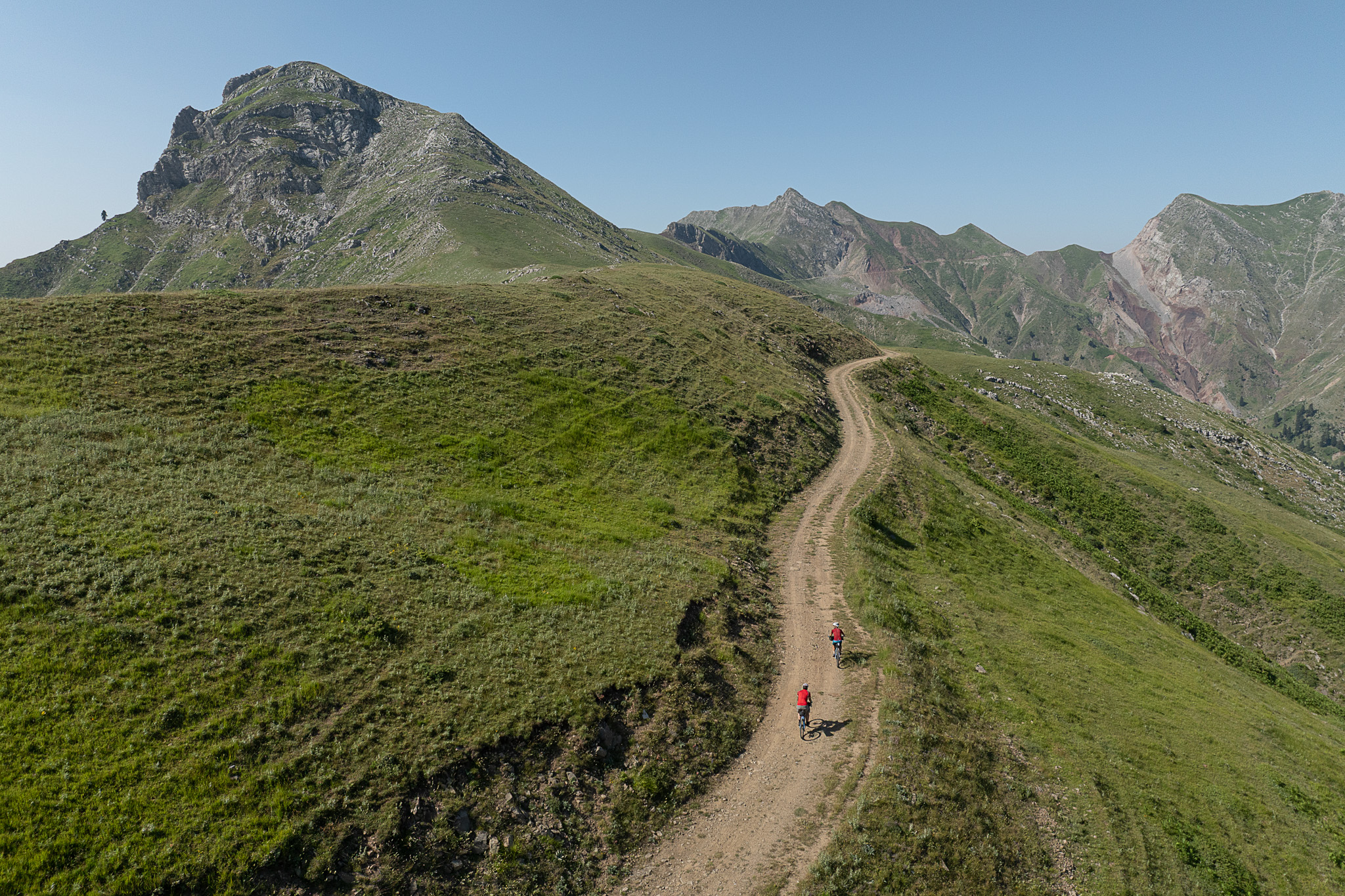
Among these roads, one stands out as perhaps the most remarkable in all of the Greek mountains: the crossing of Niala. At 1,700–1,900 meters, it skirts the peaks so closely that it almost feels possible to touch them. From here, the views stretch over the Thessalian plain and toward the western peaks of Agrafa. Yet Niala is more than breathtaking scenery—it is history. A dramatic chapter unfolded here in the spring of 1947, during one of the most intense episodes of the Greek Civil War (see “The History of Niala” below).


ROUTE DESCRIPTION
The recommended Agrafa route can be completed in three days of cycling. The longer and more challenging sections are on asphalt roads, while all descents are unpaved and highly enjoyable. Most dirt roads are regularly maintained, but their passability can be affected by weather conditions, particularly heavy rain or storms.
Water sources are available at regular intervals, and carrying two water bottles is sufficient even on very hot days. Options for ready-made food or resupply are limited, so it’s recommended to call the stops where you plan to eat in advance to avoid surprises.
Day 1: Belokómiti – Agrafa (44.2 km | 1,280 m ↑ | 1,410 m ↓)
Starting from the village of Belokómiti, we climb for 13 km along a north-facing asphalt road to the Agios Nikolaos col, above the village of Vraggiana, covering the first 700 meters of ascent.
Next comes the most scenic section of the day: a dirt road that winds between the highest peaks of eastern Agrafa and the famous Niala, ending at the pastoral settlement of Kamaria.
The day finishes with 16 km of delightful downhill cycling to the village of Agrafa, not along the main road, but via an almost unknown dirt track that crosses streams, waterfalls, and rarely-visited spots.
In the village, you’ll find 3–4 taverns and cafés for meals. For overnight stays, you can choose the Agios Dimitrios Church or, for more comfort, the guesthouses: Kyra Niki (tel. 22370 93209) and Pyrgos ton Agrafon (tel. 22370 93200).
Day 2: Agrafa – Petrilo (33.5 km | 1,220 m ↑ | 890 m ↓)
The day begins with a steep descent toward the Agrafiotis River, followed by a riverside asphalt road heading north to the junction for Epiniána. Here, the first dirt section starts, climbing alongside the river to the picturesque village of Trovato, which has two taverns. The recommended stop is “Apólafsis” in the upper neighborhood (tel. 6976284947).
Next, a challenging 10 km asphalt climb (+700 m) leads to the “Tria Synora” pass, but the effort is rewarded with a relaxing descent through fir forests and meadows to Petrilo, the second stop on the route.
In the village, the café-shop “Gkatzoudis” is a classic spot with a cycling heritage—trophies from the owner’s children decorate the space. For a proper meal and overnight stay, continue to Livádia, where the tavern-guesthouse “Ta Livadia” operates (tel. 6972 113659). Alternatively, slightly further along, you’ll find a small chapel with running water and a shelter, ideal for free camping.
Day 3: Petrilo – Belokómiti (40.3 km | 1,320 m ↑ | 1,520 m ↓)
Starting from Petrilo or Livádia, we climb north for 10 km to a chapel with a hunters’ shelter, leaving the asphalt road behind. The dirt road continues uphill for another 4 km along the slopes of Voutsikaki, before giving way to a long dirt descent to the village of Fylakti.
The descent continues on asphalt for another 3 km, leaving the final ascent to the village of Neraida. Just outside the village, a forest road gently descends, leading to the route’s endpoint.


118 km.
ROAD
DIRTROAD
BAD DIRTROAD
PATH
118 km.
ROAD
DIRTROAD
BAD DIRTROAD
PATH
ROAD
BAD DIRTROAD
DIRTROAD
PATH
GALLERY


- THE HISTORY OF NIALA
The Greek Civil War (1946–1949) was the last ideological conflict in Europe and one of the darkest chapters in modern Greek history. Greek leftists and anti-fascists were relentlessly pursued by the national army and the government. In the spring of 1947, an extraordinary and tragic episode unfolded on the Niala ridge that left a permanent mark on the land.
Isolated units of the Democratic Army, together with wounded fighters and pursued civilian families, found themselves surrounded by government troops. Their only chance of escape was to cross the Niala ridge, a treacherous path at 2,200 meters over bare, icy, and inhospitable peaks. Many realized the peril: the army could have already secured the passes, and the elements themselves threatened to wipe them out.
On April 11, in the midst of a violent storm, they began their ascent. Rolling rocks claimed some lives, and an unrelenting blizzard struck as they neared the ridge. Yet the strongest and youngest pressed on, carrying women, children, and the wounded on their backs. Many could not endure the ordeal; they fell, exhausted. Infants, children, and women perished. The three-year-old son of Vagia Raga froze to death. A woman, pursued by collaborators, had followed the march to reunite with her partisan husband—she, her baby, and her 18-year-old daughter were lost. Young men gave their lives for Niala, forming chains to protect the others, climbing and singing to sustain their courage.
By the night of Holy Saturday, April 12, the survivors reached a mountain pass and began descending toward Saika. For most, salvation came. However, the rearguard was lost in dense fog, stumbling into government army posts camped in the snow.
Then something unprecedented occurred. Fighters from both sides, recognizing their shared humanity, called out to one another: “Do not shoot—we are brothers,” “let the danger pass tonight, and tomorrow we leave.” The frozen partisans were allowed to shelter inside the soldiers’ tents for the night, leaving their rifles behind and looking each other in the eyes. No one moved. They were all children of the same homeland, divided by ideals or circumstance. They shared their food and slept side by side in the same tents.
At dawn on Easter, Colonel Aleuras, commander of the loyalist forces, realized the main body of the partisans had escaped. He called for reinforcements, claiming to have captured the “remnants of the rebels.” The partisan leader, Hermes, understood the communication and requested that the informal truce be respected. Aleuras, enraged, challenged him and fired first—but missed. Hermes shot him dead, ordered the remaining fighters to assemble, and ordered a swift retreat. Most survived.
Yet 31 partisans, weakened and trapped, were captured. Among them was Vangelio Kousiantza, a teacher from Palamas, Karditsa. They were tortured, and ten, including Vangelio, were sentenced to death.
Even in the face of imminent execution, Vangelio showed extraordinary courage. She led the dance before the firing squad, defiant and upright, refusing to break. The soldiers, moved, refused to fire, leaving the task to collaborators, who had no such compassion. Standing with her body pierced, Vangelio cheered for the justice of their cause until the final blow. Her last letter from the prison in Karpenisi read:
“Do not mourn me, do not grieve. Our sacrifice will become a beacon, illuminating the world for a better life.”
For those who choose to cycle these paths today, a stop at Niala is more than a rest. Remove your helmets. Leave a flower. Remember that beyond its breathtaking natural beauty, this land is steeped in courage, dignity, and hope for a more just world.
ROAD BOOK
| Distance between points | Total distance | Description | |
|---|---|---|---|
| 0 | 0 |  |
Starting point is the Church of the Holy Apostles, Belokomiti. Head towards the Plastira Dam |
| 2.4 | 2.4 |  |
At the 1st fork, left to the dam and Karvasara |
| 0.4 | 2.8 |  |
After the bridge, right at the fork to Karvasara and Vraggiana |
| 2.0 | 4.8 | |
At the first fork while ascending, left towards Elato |
| 8.8 | 13.6 |  |
At the end of the ascent, at the chapel of Agios Nikolaos, left on the dirt road |
| 2.9 | 16.5 | |
At the end of the ascent, right at the fork (continue on the same road) |
| 5.0 | 21.5 | |
At the fork after the Niala monument, right slightly uphill |
| 7.2 | 28.7 |  |
At the end of the descent, right at the intersection (left descends to the settlement of Kamaria) |
| 4.5 | 33.2 |  |
At the 1st road, diagonally right backward towards “Varso” |
| 4.2 | 37.4 |  |
Ignore road diagonally right backward |
| 5.6 | 43.0 |  |
After the chapel, right. Follow the cement road to Agrafa village square. Overnight |
| 1.0 | 44.0 | |
Start of second day from the square, follow signs to Karpenisi |
| 3.9 | 47.9 | |
At the end of the descent, right to Epiniana and Trovato |
| 3.2 | 51.1 | |
After the bridge, right to Trovato |
| 3.3 | 54.4 |  |
Ignore road left to Tridentro, continue straight |
| 2.5 | 56.9 | |
At the fork, left uphill to Trovato (right goes to Vraggiana) |
| 0.3 | 57.2 |  |
Ignore road diagonally left backward to Dentro and Agios Antonios |
| 2.9 | 60.1 |  |
After Agios Dimitrios church in Trovato, left uphill to the upper square |
| 0.2 | 60.3 |  |
Ignore right road to Koustesa and Vragiana, continue to upper square |
| 0.7 | 61.0 | |
After the upper square, right downhill towards Petrilo |
| 8.0 | 69.0 |  |
At the end of the ascent, straight to the intersection |
| 2.0 | 71.0 | |
At 1st intersection, left to Petrilo (right goes to Koustesa and Vraggiana) |
| 4.6 | 75.6 | |
On the main road, right to Petrilo. Cross the village, continue to Mouzaki |
| 10.1 | 85.7 | |
Just before the end of the ascent, right uphill (left goes to Vlasi) |
| 0.4 | 86.1 | |
At the top of the ascent, at Agios Nikolaos chapel, right on dirt road |
| 2.2 | 88.3 | |
At 1st fork, left uphill (right descends to Livadia) |
| 1.5 | 89.8 | |
At the end of the ascent, continue straight. Right diagonally backward goes to Kazarma peak |
| 1.2 | 91.0 |  |
At 1st road descending, diagonally left backward |
| 4.8 | 95.8 | |
Ignore road straight left, continue right downhill to the switchback |
| 3.0 | 98.8 | |
At the end of dirt road, right downhill to paved road to village |
| 0.3 | 99.1 | |
At the church, right downhill. Continue on main road to Kalyvia |
| 3.1 | 102.2 |  |
At Stathoulas fountain, right to Neraida |
| 4.0 | 106.2 | |
At Neraida square, right uphill |
| 0.1 | 106.3 | |
Ignore road left and immediately after, left downhill at switchback |
| 0.4 | 106.7 | |
At 1st dirt road, right |
| 3.3 | 110.0 | |
Ignore road straight right to Agia Paraskevi |
| 0.5 | 110.5 | |
At next road, right (straight goes to Neochori) |
| 2.3 | 112.8 | |
At the end of road, straight right on dirt road |
| 0.5 | 113.3 | |
At fork after the sheepfold, right downhill |
| 0.7 | 114 | |
At end of dirt road, left on cement road and immediately after, left on paved road |
| 1.3 | 115.3 | |
At end of road, left on main road to Belokomiti |